1. Presentation
Ever since its coming into being in 2001, the ICT Research Centre set its role to promote and investigate new construction technologies and solutions for problems occurring in geotechnical engineering, overland communication ways and topographic-geodetic measurements.
The founding members, Professor Virgil HAIDA, Eng. Ph.D., and Professor Marin MARIN, Eng. Ph.D., and their colleagues have thus diversified the classical activities of the CCTFC Department both through research contracts, research services, expert and technical consultancy as well as by forming and training highly qualified specialists including by offering them doctoral and master programs.
As a result of this activity, the ICT Research Centre works with a well-balanced multi-disciplinary team, which can offer solutions to specific problems occurring in geotechnical engineering, roads and railways, bridges and modern topographic and geodetic measurements. The national level grants as well as the research contracts closed with economic parties are proof of the high quality and advanced research offered by the centre.
The Laboratory for Geotechnics and Overland Communication Ways has been authorized by the Government Inspectorate in Constructions as Ist degree laboratory in 2001 and reauthorized in 2006, 2010, 2014 (authorization no. 2872/2014) renewed in 2018.
2. Structure and research teams
The structure of the ICT Research Center has three main research fields: (i) Roads and Railways, (ii) Geotechnics and Foundations and (iii) Terrestrial Measurements and Cadastre, fields covering the declared mission of the centre.
The field research teams are appropriate to the research activities and include qualified staff, researchers and Ph.D. students as well as renowned scientists.
Roads and Railways
- Prof. Florin BELC
- Assoc.Prof. Alexandru HERMAN
- Assoc.Prof. Ciprian COSTESCU
- Lecturer Paul MARC
- Ph.D.Student Andrei FORTON
- Ph.D.Student Alin BUZURIU
- Ph.D.Student Ligia Anda BELC
- Techn. Adrian BOLOG
Geotechnics and Foundations
- Prof. Adrian CIUTINA
- Lecturer Monica MIREA
- Lecturer Alexandra CIOPEC
- Lecturer Cristina VOICU
- Lecturer Luiza ROMAN
- Lecturer Octavian ROMAN
- Techn. Ana Baicu
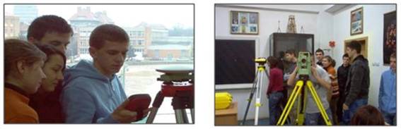
Terrestrial Measurements and Cadastre
- Prof. Carmen GRECEA
- Prof. Ion Sorin HERBAN
- Assoc.Prof. Cosmin Constantin MUŞAT
- Lecturer Viorica DAVID
- Lecturer Alina Corina BĂLĂ
- Lecturer Floarea Maria BREBU
- Lecturer Clara – Beatrice VÎLCEANU
- Lecturer Iacob NEMEȘ
- As.Prof. Maria Roberta GRIDAN
- As.Prof. Anca-Maria MOSCOVICI
- Ph.D.Student. Adrian ALIONESCU
3. Main research directions
Even since the setting up of the centre, the research teams have answered the requests of the economic environment and proposed specific research grants, thus opening new research directions which in time became the main research focus.
Roads and Railways
- designing high quality resistance structures for roads;
- improvement of road viability;
- “cold” technologies for road construction and maintenance;
- railroads without junctions;
- geometry of rails for high speed railways;
- recycling methods for road structures.
Geotechnics and Foundations
- vibration techniques in foundation problems;
- improvement of weak foundation soil through punching;
- efficient foundation systems for different constructions in seismic areas;
- investigation of foundation grounds in the laboratory and on site;
- protection and insulation solutions for buildings against vibrations transmitted through the foundation ground;
- geotechnical and foundation works based on vibration techniques, horizontal drilling;
- ensuring the stability of slopes and mountainsides;
- impact of dynamic loadings on foundations.
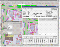
Terrestrial Measurements and Cadastre
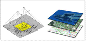
- creation of 3D models for heritage objects through digital photogrammetry;
- development of monitoring technologies for urban green areas by remote detection;
- e-Learning and OER platforms used in the geodesic field.
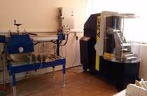
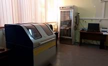
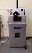
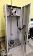
4. Research Infrastructure of the ICT Center
The laboratory equipment and informatics resources are calibrated in order to answer the requirements of the research through classical and modern devices.
Equipment:
- Testing equipment for asphalt mixtures: fatigue, flowing, elasticity module;
- Equipment for determining the characteristics of bituminous binders: penetration, ring and ball softening point, ductility, Frass breaking point, adhesiveness, RTFOT susceptibility to high temperatures, DSR and BBR rheology;
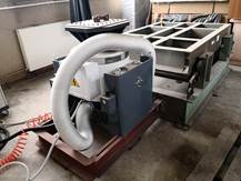
- Equipment for the determination of the physical-mechanical characteristics of asphalt mixtures: hydraulic press, Marshall press, water absorption device, centrifuge for bitumen extraction, Soxhlet device, compaction roller, Marshall hammer, mixing plant, device for cutting asphalt samples, core extractor, asphaltanalyzer, gyratory compactor, ventilated oven, device for determining the thermal features; equipment for testing asphalt mixture trapeze samples;
- Equipment for determining the physical-mechanical characteristics of natural aggregates: Los Angeles device, microDeval device, equipment for cutting and preparing samples, sand equivalent device, particle shape determination, parts that can be levigated, sieving device;
- Vibration testing system: Shaking stand, shaker, measuring, monitoring and diagnosis system, EXPERT VIBRO - DELPHIN TECHNOLOGY;
- Equipment for the determination of the compaction characteristics of soils;
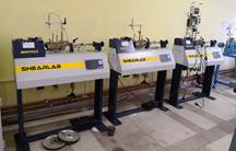
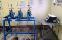
- Equipment for the determination of the mechanical characteristics of soils (Edometru, 3 pcs and CYBER-PLUS EVOLUTION with 8 CHANNELS “Extending to 16 channels”, direct shearing device with incorporated data acquisition system, 3 pcs, tri-ax device, etc.;
- Equipment for the determination of physical characteristics of soils;
- Equipment for the determination of the grading and permeability of soils: drying oven, scales, site piles, constant level permeameter, variable level permeameter ;
- Equipment for testing the foundation ground on site: dynamic penetrometer, loading plates, deformation measuring device, etc.
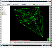
- GPS Leica SR 20 System
- Total station; TC 805 ST total station
- Electronic theodolite
- Digital cartography software for virtual analysis of 3D point cloud
- GPS-TPS+Software+precision digital level system
- 3D terrestrial laser scanner
- REC ELTA total stations
- Levels: NI 025; 007; 004; NI 1007; NI 025; NI 030;
- Digital levels : Leica 100M, 150M
- THEO 010; 010A; 020; 030; 080; DALTA 010A; Freidenger systems
- REDTA 002 tachymeter
Specialized software:
- Optimization of road network management - Soft PTV VISION VISUM for macro-simulation, soft PTV Vision VISSIM for micro-simulation;
- ProfiSignal
- DIANA TNO
- OedoLab Reports / ShearLab Reports
- Toposys 5.6
- Mapsys 7.5
- Autodesk Civil Design / Autodesk Survey / Autodesk Mapguide
- LeicaGeoOffice Tools / LeicaGeoOffice Combined
- ERDAS Imaging 9.1
- AGISOFT Photoscan
- CalibSCAN
- VeCAD
- GNSS Planning
Recent research contracts and projects
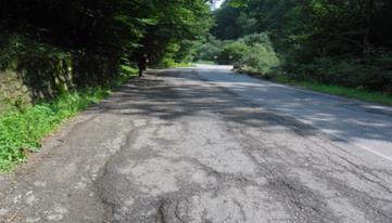
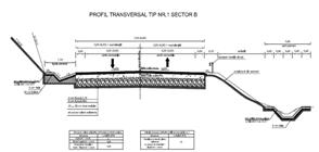
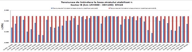
Technical Expertise DN 18 Baia Mare – Sighetu Marmatiei, Part B Km 15 + 000 – 38 + 104 and Part E Km 52 + 202 – 62 + 234
The contract involves the elaboration and delivery of the Technical Expert Report, including investigations on site, technical consultancy, type profiles and all necessary supporting documents; it implies presenting the technical expert report in front of the Beneficiary’s Technical Economical Committee.
|
|
|
|
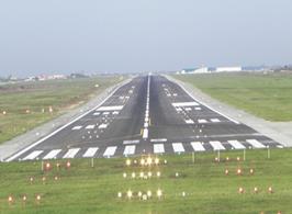
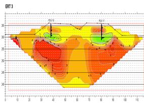
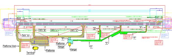
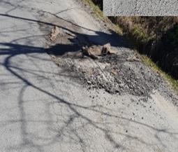
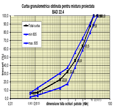
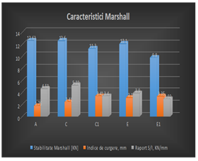
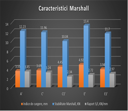
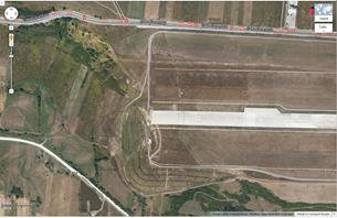
Field and Laboratory Investigations Concerning the Ground of the Safety Lane (Rwy Strip) and the Safety Area Pertaining to the Take off / Landing Runway (Resa)
Short description of the project. The contract consists in researching the characteristics of the ground on the runway through in situ and laboratory testing. The following characteristics have been determined: - for the ground in the area: grading, plasticity, consistency index; layering of the ground in the runway strip through geotechnical drilling and sounding; the bearing capacity of the ground through light dynamic penetration (PDU) and the Californian Bearing Ratio. The required value of the resistance parameter (CBR) of the soil ranges between 15 and 20%. In the case of inaccurate values, the laboratory study offered major technical solutions to obtain the required performances in respect to the bearing capacity, such as: - stabilization with special hydraulic binders; - mechanic stabilization.
|
|
|
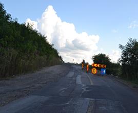
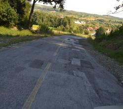
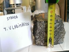
Technical and Geotechnical Reports for the Rehabilitation Works on DN76, Ionești – Vârfurile, Km 55+425 – Km 69+350 – Technical Report on Road Superstructure
The technical report aims at assessing the executed works, starting from the site documents drawn up during construction, as well as at proposing technical solutions which can be applied for finalizing the works. The theme of the report requires the highlighting of the existing technical condition of the road structure and the proposition of viable alternate solutions to continue the rehabilitation, ensuring the technical and qualitative performances while speeding up the work rhythm.
|
|
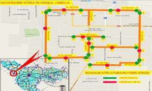
Technical Report – Modernization of Streets, Setting up Cycle Tracks in the Town of Jimbolia
Examination of the works realized on the streets and cycle tracks in the town of Jimbolia, from the point of view of the conformity of the technical characteristics and the materials with the specifications of the technical documentation based on which the works had been performed.
The non-conformities presented in detail in the reception report drawn up at the completion of the works were verified based on the design characteristics stipulated by the project.
|
|
|
|
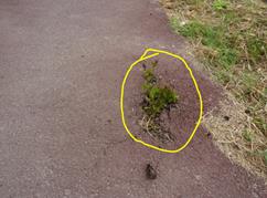
Technical Report – Streets in the City of Resita
The aim of the project is to verify the works realized on the streets covered by the technical report, from the point of view of the conformity of the technical characteristics and the quality of the materials used with the specifications of the technical documentation based on which the respective works had been realized.
|
|
|
|
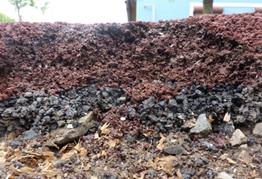
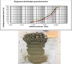
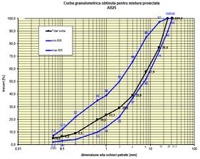
Integrated Technology for Preparing Ecological Composite Asphalt Mixtures with compounds derived from industrial wastes, used in high quality road structures (eco-asphalt)
The purpose of the project was to develop integrated technologies for the preparation of ecological composite asphalt mixtures (MAEC), added with compounds resulted from processing industrial wastes, in order to realize road structures.
|
|
|
|
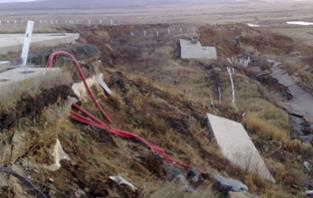
Technical-Economical Documentation Regarding the Rehabilitation Measures of the Embankment “Prag 09 – International Airport Sibiu”
The extension of the Airport runway, within the modernization and expansion works of the International Airport Sibiu, required realizing an embankment up to 28m high in the western direction. On August 2010, at the western end of the Airport runway, a collapse of the embankment occurred, manifested through the fall of the soil mass on a depth of approximately 10m in the runway axis and approximately 3-4m on the edges of the embankment. The dimension of the collapsed area is approximately 250m in length and 100m wide. The collapse of the tall embankment from the western part of the International Sibiu Airport was a very complex phenomenon, where numerous factors concurred, including the foundation ground, embankment profile, filling material used at the execution of the embankment, faults in the collection and drainage of the surface water, implemented drainage system.
 |
 |
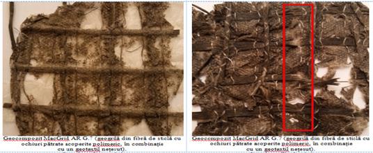
Research Concerning the Stability of the Valea Mică – Caransebeş Bypass Viaduct - 2012 – 2014
The study includes complex methods and follow-up patterns used for a road pavement realized in our country through an innovative technology, reinforced soil respectively; it suffered displacements, linear and angular deformations bordering the admitted limits for this kind of construction. The monitored viaduct was realized using the Freyssisol technology which supposes, in this case, two parallel walls in precast reinforced concrete elements, locked with reinforcement in the earthworks, synthetic fiber reinforcement. The installation of the reinforcement and wall panel is realized progressively, with the realization of the filling. The reinforcement is supposed to support the retaining wall as well as to strengthen the earth embankment between the retaining walls.
Technical Expert Report TMD Friction Hall and Administrative Building -2014
The object of the contract was to follow up the displacements and the elements of the resistance structure of the hall and administrative building for the objective TMD FRICTION placed in the city of Caransebeş. The general working method used was the highly precise geometric contouring method since it ensures the highest accuracy in measuring the vertical displacements in buildings. It was used both for the experimental testing of constructions on models or nature scale, and for the follow-up of the operation behavior in time.
Follow-up of the time behavior in earthworks at the passageways:
- Sebeş, km 4+725 – abutment A2 (C2);
- Potoc, km 5+512 – abutment A1(C1) și A2(C2);
- Valea mare, km 7+107 – abutment A1(C1) și A2(C2);
- Valea mică, km 7+375 – passageway in reinforced earth on the bypass Caransebeș - 2014 – 2015
The cadastral measurements aimed at determining the absolute values of the displacements at the level of the road surface as well as at the level of the infrastructure elements. The highly precise geometric contouring method and the precise trigonometric contouring were used observing the stipulations in STAS 2745/90 and STAS 3300/2-85.
The dates of the measuring campaigns: 20-25 October 2014; 5-16 January 2015; 14-20 March; 15-20 June; 23 September - 4 October.
The elements measured on site were processed and compensated.
Development of the Monitoring Technologies for Urban Green Areas through Remote Detection. Comparative research Timişoara-Romania and Beijing-China 2016 - present
Nowadays the urban population worldwide exceeds 50% and, according to the most recent studies, over 60% of the entire population (4,9 billion people) will live in urban areas by the year 2030. In such a developing process, the city faces a series of transformations and problems referring to: air pollution, pollution with solids, significant reduction of green areas in line with the increase of grey areas, degradation of water and environment quality.
In this context, the University Politehnica Timişoara launched a research project entitled ”Development of the Monitoring Technologies for Urban Green Areas through Remote Detection. Comparative study Timişoara – România and Beijing – China”, together with the Institute of Remote Sensing and Digital Earth (RADI), working within the Chinese Academy of Sciences (CAS). RADI is the most important research institute in this field and its immediate goals are the research on the modeling and assessment of urban green areas.