Iron Gates (Danube)
The post conference tour is a full one day trip, which combine a technical visit to the Iron Gate I Hydroelectric Power Station and, a tour by boat to the Iron Gates, the gorge on the Danube River.
| Registration | Before 15.04.2011 | 16.04.2011 to 30.08.2011 | Cash at the Registration Desk |
|---|---|---|---|
| Post-conference tour (lunch and dinner included) Departure: 8:oo Arrival: 21:oo (approx.) |
90 € | 95 € | 100 € |
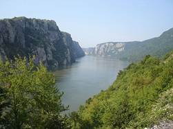
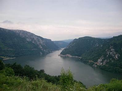
The Iron Gates (Romanian: Porţile de Fier) is a gorge on the Danube River. The gorge lies between Romania in the north and Serbia in the south. At this point, the river separates the southern Carpathian Mountains from the northwestern foothills of the Balkan Mountains.
 |
 |
| Danube River near Iron Gate | |
Gorges
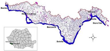
The first narrowing of the Danube lies beyond the Romanian isle of Moldova Veche and is known as the Golubac gorge. It is 14.5 km long and 230 m wide at the narrowest point. At its head, there is a medieval fort at Golubac, on the Serbian bank. Through the valley of Ljupovska lies the second gorge, Gospodin Vir, which is 15 km long and narrows to 220 m. The cliffs scale to 500 m and are the most difficult to reach here from land. The broader Donji Milanovac forms the connection with the Great and Small Kazan gorge, which have a combined length of 19 km. The Orşova valley is the last broad section before the river reaches the plains of Wallachia at the last gorge, the Sip gorge.
 |
 |
| The Kazans – aerial view | The Tabula Traiana plaque |
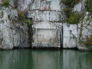
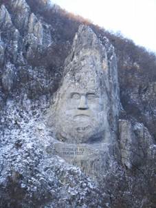
The Great Kazan (kazan meaning "boiler") is the most famous and the narrowest gorge of the route: the river here narrows to 150 m and reaches a depth of up to 53 m. East of this site the Roman emperor Trajan had the legendary bridge erected by Apollodorus of Damascus. Construction of the bridge ran from 103 through 105, preceding Trajan's conquest of Dacia. On the right bank a Roman plaque commemorates him. On the Romanian bank, at the Small Kazan, the likeness of Trajan's Dacian opponent Decebalus was carved in rock from 1994 through 2004.
Significantly older treasures have been unearthed in the geographically less spectacular gorge of Gospodin Vir: in the 1960s the archaeological survey Lepenski Vir was unearthed, the most significant in Southeast Europe. The sandstone statues from the early Neolithic are particularly splendid. Along with the other surveys that can be found in the Iron Gates, it indicates that the region has been inhabited for a very long time.
 |
 |
| Decebalus statue | Danube at the narrowest point of the Iron Gates |
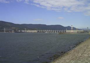
The Dam
The construction of the joint Romanian-Yugoslavian mega project that would finally tame the river commenced in 1964. In 1972 the Iron Gate I Dam was opened, followed by Iron Gate II Dam, in 1984, along with two hydroelectric power stations and two sluices.
The construction of these dams gave the valley of the Danube below Belgrade the nature of a reservoir, and additionally caused a 35 m rise in the water level of the river near the dam. The old Orşova, the Danube island Ada Kaleh and at least five other villages, totaling a population of 17,000, had to make way. People were relocated and the settlements have been lost forever to the Danube. The dam's construction had a major impact on the environment. The flora and fauna, as well as the geomorphological, archaeological and cultural historical artifacts of the Iron Gates have been under protection from both nations since the construction of the dam.
 |
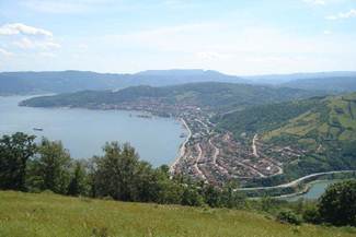 |
| Iron Gate I Hydroelectric Power Station | Orşova City – aerial view |
Please folow this link to download the Post Conference Tour information.